चम्बल (चमर्ण्वती/कामधेनु/सदावाहिनी/मालवगंगा )
चम्बल नदी मध्यप्रदेश में इंदौर जिले में महू छावनी के निकट स्थित जिले की जनापाव पहाड़ी से निकलती है। जनापाव पहाड़ी से निकलकर यह नदी चौरासीगढ़ ,मप्र, के पश्चात् भैंसरोड़गढ़ ,चित्तौड़गढ़ के समीप राजस्थान में प्रवेश करके चित्तौड़गढ़,कोटा, बूंदी, सवाई माधोपुर, करौली एवं धौलपुर छ: जिलों में बहते हए उत्तर प्रदेश में प्रवेश करके कुल 966 किमी बहकर मुरादगंज, इटावा, उत्तरप्रदेश के निकट यमुना में मिल जाती है।
राज्य में इसकी लम्बाई 153
किमी है। कुछ पुस्तकों में यह लंबाई 135
किमी मिलती है। महर्षि परशुराम की तपोस्थली
रामेश्वर धाम, सवाईमाधोपुर में इसमें आकर बनास व सीप
नदियाँ मिलती हैंए जो त्रिवेणी संगम कहलाता है।
भैंसरोड़गढ़ ,चित्तौड़गढ़
के निकट चम्बल नदी चूलिया जल प्रपात ऊँचाई 18 मी
बनाती है। चम्बल राजस्थान की सबसे लम्बी, सबसे
बड़े अपवाह क्षेत्र वाली एवं एकमात्र नित्यवाही नदी है। राजस्थान में सर्वाधिक
सतही जल ले जाने वाली नदी यही है। चम्बल नदी सर्वप्रथम कोटा एवं बूंदी तथा
तत्पश्चात कोटा एवं सवाई माधोपुर जिलों के मध्य सीमा बनाती है।
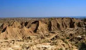
बीहड़ भूमि
राजस्थान एवं मप्र की सीमा पर चम्बल का
प्रवाह क्षेत्र बीहड़ भूमि है जो से कृषि के लिए अनुपयुक्त है। सदियों से यह
क्षेत्र असामाजिक गतिविधियों के लिए चर्चित रहा है।
राज्य में सबसे अधिक अवनालिका अपरदन यहीं पर
हुआ है फलस्वरूप यहाँ बीहड़ भूमि बन गई हैं। चम्बल के बीहड़ों एवं आसपास के
क्षेत्र को राजस्थान में डांग क्षेत्र कहा जाता है।
बाँध
- चम्बल पर कुल चार बाँध बनाये गये हैं
- गांधी सागर बांध :- मंदसौर.मप्र
- राणा प्रतापसागर बाँध :-चित्तौड़गढ़
- जवाहर सागर बाँध :-कोटा-बूँदी
- कोटा बैराज :- कोटा
उपर्युक्त बाँधों में गांधी सागर की भराव क्षमता सर्वाधिक है। राजस्थान में चम्बल पर बना सबसे बड़ा बाँध राणा प्रताप सागर है। राज्य में सर्वाधिक जल भण्डारण क्षमता वाला बाँध चम्बल नदी राजस्थान एवं मध्यप्रदेश के बीच 241 किमी तक सीमा का निर्धारण करती है। इस सीमा पर राज्य के सवाईमाधोपुर करौली एवं धौलपुर जिले स्थित है। यह भारत में सबसे लम्बी अन्तर्राज्यीय नदी जल सीमा रेखा है।
बनास, पार्वती,
कालीसिंध, बामनी,
कुराल एवं मेज चम्बल की प्रमुख सहायक नदियाँ
हैं
चम्बल की सहायक नदियाँ एवं उद्गम स्थल
- बामनी :- भैंसरोड़गढ़, चित्तौड़गढ़
- कालीसिंध :- नानेरा कोटा
- पार्वती :- पाली, सवाईमाधोपुर
- नेवज :- मवासा
- बनास:- रामेश्वर, सवाईमाधोपुर
english translet
Bay of Bengal drainage system
Chambal (Charmanvati/Kamdhenu/Sadvahini/Malvaganga)
Chambal river originates from Janapav hill of the district situated near Maha Cantonment in Indore district of Madhya Pradesh. Originating from Janapav hill, this river enters Rajasthan near Bhainsrodgarh (Chittor) after Chaurasigarh (MP) and flows through six districts of Chittorgarh, Kota, Bundi, Sawai Madhopur, Karauli and Dholpur and enters Uttar Pradesh totaling 966 km. It flows and joins Yamuna near Muradganj (Etawa-Uttar Pradesh). Its length in the state is 153 km. is. In some books this length is 135 km. Meets. The Banas and Oyster rivers meet at Rameshwar Dham (Sawaimadhopur), the taposthali of Maharishi Parashuram, which is called Triveni Sangam.
Near Bhainsrodgarh (Chittorgarh), Chambal river forms the
Chulia Falls (height 18 m). Chambal is the longest, largest drainage and the
only river in Rajasthan. This is the river carrying maximum surface water in
Rajasthan. Chambal river first forms the boundary between Kota and Bundi and
then between Kota and Sawai Madhopur districts.
rugged land
Rajasthan and M.P. The Chambal flow area on the border is rugged land, which is unsuitable for agriculture due to its 'Bad land topography'. For centuries this area has been known for anti-social activities.
Most of the effluent erosion in the state has taken place
here, as a result 'rugged land' has become here. The ravines of Chambal and the
surrounding area are called 'Dang Kshetra' in Rajasthan.
bind
A total of four dams have been built on Chambal.
- Gandhi Sagar Dam (Mandsaur-M.P.),
- Rana Pratapsagar Dam (Chittorgarh),
- Jawahar Sagar Dam (Kota-Bundi)
- Kota Barrage (Kota)
Gandhi Sagar has the highest filling capacity among the above dams. Rana Pratap Sagar is the largest dam built on Chambal in Rajasthan. (The dam with the highest water storage capacity in the state) Chambal river determines the boundary between Rajasthan and Madhya Pradesh for 241 km. Sawai Madhopur, Karauli and Dholpur districts of the state are situated on this border. It is the longest inter-state river water boundary line in India.
Banas, Parvati, Kalisindh, Bamni, Kural and Mej
are the major tributaries of Chambal.
The
tributaries and confluence of Chambal are
- Bamni : Bhainsrodgarh (Chittorgarh)
- Kalisindh : Nanera (Kota)
- Parvati :- Pali (Sawaimadhopur)
- Navaj :- Mvasa
- Banas
:- Rameshwar (Sawaimadhopur)


