सिरोही जिला {देवो की नगरी }
परिचय
- सिरोही राजस्थान के दक्षिण-पश्चिम में स्थित एक पर्वतीय प्रदेश है। कर्नल टॉड के अनुसार इसका मूल नाम शिवपुरी था। राजस्थान का एकमात्र पर्वतीय स्थल माउंटआबू इसी जिले में स्थित है। यह प्रदेश, मौर्य, क्षत्रक, हूण, परमार, राठौड़, चौहान एवं गुहिल शासकों के अधीन रहा है। यह गुर्जर क्षेत्र का एक भाग था।
- 1405 ईस्वी में राजा शिवभान ने एक स्थापना की जिसे शिवपुरी के नाम से जानते है उसके पुत्र सहसमल ने शिवपुरी से 2 मील आगे 1425 ई. में एक नया नगर बसाया जिसे वर्तमान में सिरोही के नाम से जाना जाता है। अरावली पर्वत श्रृंखला के दक्षिण-पश्चिम का हिस्सा सिरोही जिले का भाग है।
- यहाँ पाषाणकालीन औजार खोजे गए हैं, ये औजार चन्द्रावती नदी के किनारे पाए गए हैं । चन्द्रावती पूर्व मध्यकाल में आबू शाखा के परमारों की राजधानी थी। कर्नल टॉड ने लिखा है कि यहाँ 999 मंदिर थे। इसकी चर्चा करते हुए गौरीशंकर हीराचन्द ओझा ने मंदिरों की बहुतायत के कारण इसकी महिमा का गुणगान किया है।
- सिरोही व आबू क्षेत्र में गरासिया आदिवासियों द्वारा बिना किसी वाद्य यंत्र के वालर नृत्य किया जाता है।
भौगोलिक परिदृश्य
- भौगोलिक स्थिति- राजस्थान के दक्षिण-पश्चिम में गुजरात से सटा हुआ सीमावर्ती जिला। अरावली श्रृंखलाओं में स्थित इस जिले में अरावली के सर्वोच्च शिखर पाए जाते हैं। राजस्थान की सबसे ऊँची चोटी गुरुशिखर {माउंट आबू} इसी जिले में स्थित है।
- अक्षांशीय स्थिति- 24°25 से 25°17' उत्तरी अक्षांश।
- देशान्तरीय स्थिति- 72°16' से 73°10' पूर्वी देशान्तर।
- क्षेत्रफल- 5136 वर्ग किमी.।
- तहसील- पिंडवाड़ा, आबू रोड, रियोदर, सिरोही, शिवगंज।
- लोकसभा क्षेत्र- जालौर ।
- विधानसभा क्षेत्र- सिरोही, पिंडवाड़ा-आबू, रियोदर।
- प्राचीन नाम- शिवपुरी और अबुर्द्धाचल प्रदेश।
- भौगोलिक उपनाम- राजस्थान का शिमला (माउंटआबू), देवों की नगरी।
- पड़ोसी राज्य- गुजरात।
- पड़ोसी जिले- पाली, उदयपुर, जालौर।
- प्रमुख स्थान- सिरोही, आबूरोड, पिण्डवाड़ा, शिवगंज, रेवदर।
- स्थलाकृति- अरावली पर्वत श्रृंखलाओं के दक्षिण पश्चिमी भाग में सिरोही स्थित हैं। राजस्थान में अरावली पर्वतों की सर्वाधिक ऊँचाईयाँ सिरोही जिले में मिलती हैं। यहाँ का आबू पर्वत राजस्थान का एकमात्र पर्वतीय स्थल है। गुरु शिखर (माउंट आबू) यहाँ का सर्वोच्च शिखर है। जिसकी ऊँचाई 1722 मीटर हैं। कर्नल जेम्स टॉड ने इसे देवों का शिखर कहा है। यह हिमालय और नीलगिरी के बीच स्थित भारत की सबसे ऊँची चोटी है।
- सिरोही में स्थित सेर (1597 मीटर) राजस्थान की दूसरी सबसे ऊँची चोटी है। यहाँ का अधिकांश भाग रेगिस्तानी है।
- नदियाँ- पश्चिमी बनास।
- जलाशय/झीलें- नक्ली झील (राजस्थान की सबसे ऊँची झील), चंदेला जुबली तालाब, आखैलाव, जावाल।
- जलवायु- सिरोही जिले की जलवायु स्वास्थ्यवर्द्धक है।
राजस्थान में सर्वाधिक वर्षा का स्थान माउंट आबू है, जहाँ 150 सेमी. वर्षा होती है इसीलिए इसे राजस्थान का चेरापूँजी भी कहा जाता है। आबू में ऊँचाई के कारण उष्ण कटिबंधीय जलवायु भी मिलती है।
सर्दियों में यहाँ का तापमान 0°C तक पहुँच जाता है।
- मिट्टी- लाल-पीली मिट्टी।
- वनस्पति- विलायती बबूल, सालर, धोकड़ा, सिरस, तेन्दू, खैर, कमूठा, बहेड़ा, बाँस। आबू पर्वत के ऊँचे भागों में उपोष्ण कटिबंधीय वनस्पति पाई जाती है। यहाँ 31 प्रतिशत भाग पर वन पाए जाते हैं।
- वन्य जीव- आबू पर्वत अभयारण्य यहाँ स्थित है। इसमें मुख्यत: पेंथर, भालू, जंगली सूअर, लंगूर, भेड़ियाँ, लोमड़ी, जरख, सियार, खरगोश, जंगली मुर्गा, जुगली बिल्ली, बिजू, बुलबुल, तीतर, बटेर आदि वन्यजीव मिलते हैं।
- पशुपालन और डेयरी- कांकरेज नस्ल की गाय सिरोही में मिलती है।
- जल परियोजनायें-
- पश्चिमी बनास परियोजना,
- कादम्बरी परियोजना
- बींठा परियोजना।
- कृषि/फसलें- गेहूँ, जौ, चना, ईसबगोल, सरसों, मक्का, बाजरा, ग्वार, दालें, कपास, मूंगफली। चीकू उत्पादन में अग्रणी।
- खनिज- केल्साइट, वोल्स्टोनाइट, चूना पत्थर, संगमरमर (आबू रोड), ग्रेनाइट, टंगस्टन (बालदा क्षेत्र)। राज्य में वोल्स्टोनाइट का सर्वाधिक उत्पादन सिरोही के वेल्का और खिरला क्षेत्रों में होता है।
- उद्योग- पर्यटन उद्योग।
- हस्तशिल्प- तलवारें, कटारें, चाकू, छुरै, भाले, मोटे कपड़े की बुनाई और रंगाई-छपाई, संगमरमर का सामान। परिवहन- राष्ट्रीय राजमार्ग संख्या 14 और 76 सिरोही जिले से होकर गुजरते हैं। 76 नम्बर का राजमार्ग पिंडवाडा से शिवपुरी तक जाता है।
दर्शनीय स्थल
माउंट आबू-


यह राजस्थान का एकमात्र पर्वतीय पर्यटक स्थल है, इसे सैलानियों का स्वर्ग भी कहा जाता है। केन्द्रीय वन एवं पर्यावरण मंत्रालय ने माउंट आबू को इको सेंसटिव जोन घोषित किया है। यहाँ के प्रमुख आकर्षण निम्नलिखित हैं
नक्की झील-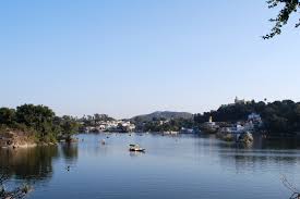

यह राजस्थान की सबसे ऊँची झील है जो सर्दियों में जम जाती है। एक किंवदंती के अनुसार इसका निर्माण देवताओं ने अपने नाखूनों से खोद कर किया था।
सनसेट पॉइन्ट-

टॉड रॉक और नन रॉक-

अबुर्दा देवी का मंदिर-
यह मंदिर माउंट आबू में ऊँची पहाड़ी पर गुफा के मध्य स्थित है। इसे राजस्थान की वैष्णों देवी माना जाता है।
देलवाड़ा के मंदिर-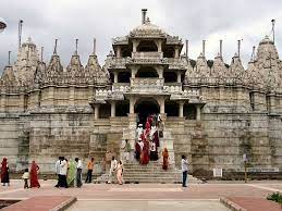

नक्ली झील से 2 किमी. दूर स्थित यह जैन मंदिर अपनी शिल्प कला के लिए विख्यात है, इनमें विमलशाह तथा वास्तुपाल के मंदिर विशेष रूप से प्रसिद्ध हैं। विमलशाह का मंदिर (1032) प्रथम जैन तीर्थंकर को समर्पित है। इसे विमलसही मंदिर भी कहते हैं। दूसरा मंदिर 22वें तीर्थंकर नेमिनाथ को समर्पित है। इसका निर्माण 1231 में वास्तुपाल एवं तेजपाल ने करवाया था। इसे लूणसही भी कहते हैं।
अचलगढ़-
देलवाड़ा मंदिर से 5 किमी. उत्तर-पूर्व में अचलगढ़ का किला स्थित है, जिसका निर्माण महाराणा कुम्भा ने करवाया। यहीं अचलेश्वर महादेव का प्रसिद्ध मंदिर है।
गुरुशिखर-

अरावली पर्वत की सबसे ऊँची चोटी गुरुशिखर माउंटआबू में स्थित है, जिसकी ऊँचाई समुद्र तल से 1722 मीटर है। यह हिमालय व नीलगिरी पर्वतों के बीच भारत की सबसे ऊँची चोटी है। गुरु शिखर को कर्नट टॉड ने 'सन्तों का शिखर' (God Olympiad) कहा है।
Other District Rajasthan :-
Sirohi District {City of Gods}
introduction
Sirohi is a mountainous state located in the south-west of Rajasthan. According to Colonel Tod, its original name was Shivpuri. Mount Abu, the only hill station of Rajasthan, is located in this district. This region has been under Maurya, Kshatrak, Hun, Parmar, Rathor, Chauhan and Guhil rulers. It was a part of the Gurjar region.
In 1405 AD, King Shivbhan established an establishment which is known as Shivpuri, his son Sahasmal, 2 miles ahead of Shivpuri, established a new city in 1425 AD, which is currently known as Sirohi. The south-west part of the Aravalli mountain range is part of Sirohi district.
Stone tools have been discovered here, these tools have been found on the banks of river Chandravati. Chandravati was the capital of the Paramaras of the Abu branch in the early medieval period. Colonel Tod has written that there were 999 temples here. Talking about it, Gaurishankar Hirachand Ojha has praised its glory due to the abundance of temples.
In Sirohi and Abu region, the Valar dance is performed by the Garasiya tribesmen without any musical instruments.
geographical landscape
Geographical Location- Border district adjoining Gujarat in the south-west of Rajasthan. Situated in the Aravalli ranges, the highest peaks of the Aravallis are found in this district. Mount Abu, the highest peak of Rajasthan, is located in this district.
Latitude - 24°25 to 25°17' north latitude.
Longitudinal position- 72°16' to 73°10' East longitude.
Area - 5136 sq. km.
Tehsil- Pindwara, Abu Road, Ryodar, Sirohi, Shivganj.
Lok Sabha constituency- Jalore.
Assembly constituencies- Sirohi, Pindwara-Abu, Ryodar.
Ancient names- Shivpuri and Aburdhachal Pradesh.
Geographical surname- Shimla (Mount Abu) of Rajasthan, the city of gods.
Neighboring state- Gujarat.
Neighboring districts- Pali, Udaipur, Jalore.
Major places- Sirohi, Abu Road, Pindwara, Shivganj, Revdar.
Topography- Sirohi is situated in the south western part of the Aravalli mountain ranges. In Rajasthan, the highest heights of the Aravalli mountains are found in Sirohi district. The Abu mountain here is the only hill station in Rajasthan. Guru Shikhar (Mount Abu) is the highest peak here. Whose height is 1722 meters. Colonel James Todd called it the pinnacle of the gods. It is the highest peak in India situated between the Himalayas and the Nilgiris.
Ser (1597 m) located in Sirohi is the second highest peak of Rajasthan. Most of the area here is desert.
Rivers- Western Banas.
Reservoir/lakes- Nakli Lake (highest lake in Rajasthan), Chandela Jubilee Pond, Akhilao, Jawal.
Climate- Sirohi district has a healthy climate.
The place of highest rainfall in Rajasthan is Mount Abu, where 150 cm. It rains, hence it is also called Cherrapunji of Rajasthan. Due to the altitude in Abu, a tropical climate is also found.
The temperature here reaches 0°C in winter.
Soil- Reddish-yellow soil.
Vegetation- Solanaceous Acacia, Salar, Dhokra, Sirus, Tendu, Khair, Kamutha, Bahera, Bamboo. Sub-tropical vegetation is found in the higher parts of Mount Abu. Forests are found here on 31 percent of the area.
Wildlife – The Abu Parvat Sanctuary is located here. Wildlife mainly found in this is Panther, Bear, Wild Boar, Langur, Wolves, Fox, Jark, Jackal, Rabbit, Wild Rooster, Jugli Cat, Biju, Bulbul, Pheasant, Quail etc.
Animal Husbandry and Dairying – Kankrej breed cow is found in Sirohi.
Water Projects-
- Western Banas Project,
- Kadambari Project
- Bentha Project.
Agriculture/Crops- Wheat, Barley, Gram, Isabgol, Mustard, Maize, Bajra, Guar, Pulses, Cotton, Groundnut. A leader in Chickpea production.
Minerals- Calcite, Wolstonite, Limestone, Marble (Abu Road), Granite, Tungsten (Balda area). The maximum production of wolstonite in the state is in the Velka and Khirla regions of Sirohi.
Industry- tourism industry.
Handicrafts - swords, daggers, knives, knives, spears, weaving and dyeing of coarse cloth, marble goods. Transport- National Highways 14 and 76 pass through Sirohi district. The highway number 76 goes from Pindwara to Shivpuri.
Scenic Spots
Mount Abu-
It is the only hill station in Rajasthan, it is also called the paradise of tourists. The Union Ministry of Forest and Environment has declared Mount Abu as Eco-sensitive Zone. Following are the major attractions here
Nakki Lake-
It is the highest lake in Rajasthan which freezes in winter. According to a legend, it was built by the gods by digging them with their nails.
sunset point-
This place is famous for the sunset view which is in Mount Abu.
Toad Rock and Nun Rock-
Two rocks named Toad Rock and Nun Rock are situated to the west of Nakki Lake in Mount Abu. Toad Rock resembles a frog, while Nun Rock resembles a woman with a veil removed
Aburda Devi Temple-
This temple is situated in the middle of a cave on a high hill in Mount Abu. It is considered to be the Vaishno Devi of Rajasthan.
Temples of Delwara-
2 KM from Nakli Lake. This Jain temple located far away is famous for its craftsmanship, among which the temples of Vimalshah and Vastupal are particularly famous. The temple of Vimalshah (1032) is dedicated to the first Jain Tirthankara. It is also called Vimalsahi Temple. The second temple is dedicated to the 22nd Tirthankara Neminath. It was built in 1231 by Vastupal and Tejpal. It is also called lunsahi.
Achalgarh-
5 KM from Delwara Temple. In the north-east lies the fort of Achalgarh, which was built by Maharana Kumbh.
I got it done. Here is the famous temple of Achaleshwar Mahadev.
Gurushikhar-
Gurushikhar, the highest peak of the Aravalli Mountains is located in Mount Abu, whose height is 1722 meters above sea level. It is the highest peak in India between the Himalayas and the Nilgiri Mountains. Guru Shikhar has been called the 'Shikhar of the Saints' (God Olympiad) by Cornut Tod.
Other District Rajasthan :-


